Editrail
Download URL | Author URL | Software URL | Buy Now ($0)
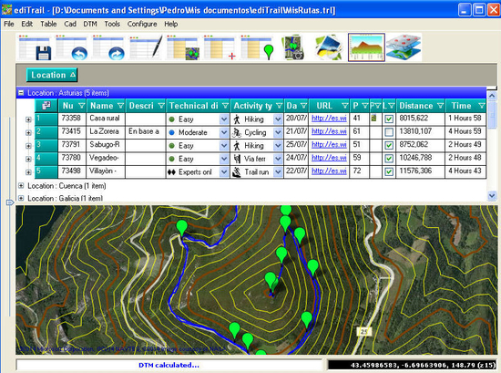
Importation/Exportation: Import/export trails to gpx file. Unlimited number of trails, and TrackPoints. Export to gpx, Excel, PDF, XPS and KML/KMZ.
Data table: Very flexible data table that allows sorting by columns, with inheritance of data, attributes, etc.
Presentation on map: View on map in accordance with the active trail, which comes from providers of maps, as in 'Satellite' mode (photos, orthophotos, etc), as 'Map' mode, (Topographic map, street maps, etc).
Digital Terrain Model, DTM: I have downloaded all the files, patches, with elevations of a point every 90 metres from around the world and 30 meters for United States, (DEM, digital elevation model), taken by the 'Shuttle Radar Topography Mission', SRTM. I've put all these files on a dedicated server that can access all from anywhere.
And with these files is created the DTM and contouring map of that we are seeing on the map in that moment.
Longitudinal profile: Profile with direct and reciprocal relationship with the Trac
Related software (5)
Geozip
Geozip calculates distance between US (optionally Canadian) zip codes or geographical coordinates. You can choose miles, kilometers or nautical miles output.

PrettyEarth - World Atlas and Maps, GPS
View beautiful maps of Earth with PrettyEarth! See current day and night regions, learn geography by taking the quiz, enjoy relief elevation surfaces, measure distances between loc ...
HoudahGeo
HoudahGeo is a photo geocoding and geotagging tool. Use HoudahGeo to attach GPS coordinates and location names to your photos. HoudahGeo writes EXIF and XMP geotags to JPEG and RA ...
IP2Location DB22 Database
IP2Location IP-COUNTRY-REGION-CITY-LATITUDE-LONGITUD E-ZIPCODE-TIMEZONE-ISP-DOMAIN-NETSPEED-A REACODE-WEATHER-MOBILE-ELEVATION is commercial IP geolocation translates IP address to c ...
Geodata International
Geodata International - World-wide database of countries with georeferenced towns, municipalities, postal codes and administrative units with WGS84 and UTM coordinates and elevatio ...
