Geozip
Download URL | Author URL | Software URL | Buy Now ($49)
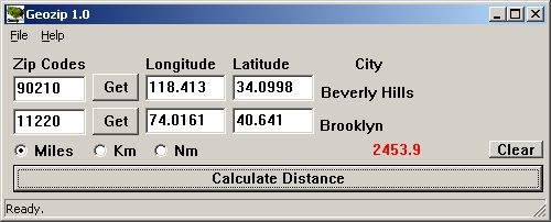
Geozip calculates distance between US (optionally Canadian) zip codes or geographical coordinates, latitude and longitude. It does take into account the curvature of the earth for calculating. You can choose miles, kilometers or nautical miles output. Customixation is available if you need more specific applications using the Geozip geographical distance calculations.
Related software (5)

PrettyEarth - World Atlas and Maps, GPS
View beautiful maps of Earth with PrettyEarth! See current day and night regions, learn geography by taking the quiz, enjoy relief elevation surfaces, measure distances between loc ...

World Cities Database Viewer Program
World Cities Database with Latitude Longitude and time zone Info Global World

TRANSDAT
TRANSDAT Coordinate Conversion supports thousands of coordinate systems and geodetic datum shifts, user-defined systems, INSPIRE, NTv2, BeTA2007, GPS, continental drift, Shape, KML ...

Geodata International
Geodata International - World-wide database of countries with georeferenced towns, municipalities, postal codes and administrative units with WGS84 and UTM coordinates and elevatio ...

ORTWIN
ORTWIN is a program for the inquiry of localities in Germany. It finds postal zip codes, telephone pre selections, coordinates. It performs perimeter searches and distance calculat ...
